
Dew Point and NOAA’s Digital Weather Website
It was foggy on the Maine coast on August 10 and 11. Fog is common in the months of August and September in the coastal northeast. Fog doesn’t phase fishermen. They either know their territory very well without visible clues, or they use their electronics to navigate when the visibility is low.
On August 10, when I was visiting on Squirrel Island off Boothbay Harbor, ME, my friends (not fishermen) were trying to decide if they could motor from Squirrel to Robinson’s Lobster Restaurant on Southport Island, have dinner, and get back before the forecasted fog reduced visibility to ¼ mile or less. This was the perfect situation in which to use the concept of dew point to help make the decision.
Dew point (or dew temperature, as it is also known) is the temperature that the air must reach in order for serious fog to be present. It is a measure of humidity. The dew point varies depending on the air temperature and the amount of moisture in the air. For example, when the air is cold in the winter, the dew point will be lower because cold air does not hold as much moisture as warm air. When you know the dew point and the temperature of the ambient air over a given time period, you can predict when the fog will close in.
To predict fog, all you need is a weather app on your phone that provides both hourly ambient temperature and dew point or the new digital weather website that NOAA, the Department of Commerce and the National Weather Service have launched at http://digital.weather.gov. This site is very comprehensive. The categories include Alerts, Past Weather, Current Conditions, Forecasts, Information Center, Weather Safety, News, Education, and About. Under each category are a number of subcategories.
The digital weather website
Under Forecasts (marine) at http://digital.weather.gov you will find regional coastal forecasts, including graphical wind, wave and surf forecasts. You can also find specific local forecasts by entering latitude and longitude coordinates or by clicking on a particular location on the map.
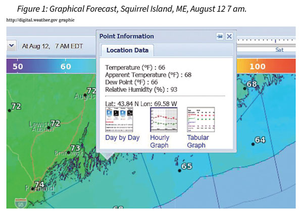
Figure 1 shows the specific information for Squirrel Island on August 12 at 7 am. Notice that the information in the box contains temperature, apparent temperature, dew point, and relative humidity. As you can see, the dew point and the temperature are exactly the same, so we would expect fog. And indeed, I can confirm from the front porch that I cannot see Southport Island at this hour of 7 am.
Clicking on the Graphical Forecast revealed 48 hours of weather data, and clicking on the Tabular Forecast revealed 48 hours of weather data in tabular form. From the list of variables in tabular form, I chose temperature, dew point, and fog – and could easily determine by comparing temperature and dew point that we are not due for any serious fog for the next 48 hours. Sure enough, the “fog” entry says “patchy” at various times over the next 48 hours when the dew point and temperature are within several degrees of each other.
There are many other variables on that website which will be helpful to fishermen and non-fishing mariners. It is a website I would recommend becoming familiar with and to which we older fishermen and mariners should introduce the younger generation. Wave periods, wind speed, wind direction, visibility, and many other variables – all can be extremely helpful inputs for those planning fishing or recreational trips.
Back to dinner at Robinsons
Thanks to the Weather Channel on my phone (I did not know about the digital website at this time) it was clear that the temperature of 64°F was going to hold for a few hours. Therefore, given that the ambient temperature would not be equal to the dew point of 63°F for a while, the folks who wanted to motor to Robinson’s or Boothbay Harbor for dinner had time to make their run for food.
And that is what they did, making it safely back with takeout before the fog set in.
Ann Backus, MS, is the director of outreach for the Harvard School of Public Health’s Department of Environmental Health in Boston, MA. She may be reached by phone at (617) 432-3327 or by e-mail at <abackus@hsph.harvard.edu>.
FISH SAFE:
Make use of weather science and the excellent weather tools now available for marine trip planning.
Become familiar with the new digital weather data and forecasts available through http://digital.weather.gov.
Share your knowledge and these tools with the next generation.